By The Snowflake: Traverse City's Fiercest Winter Storms
By Ross Boissoneau | Feb. 6, 2022
Traverse City escaped the brunt of a massive winter storm this past week -- but we haven’t always. So the Ticker dusts off the local history books to explore the biggest blizzards to hit the region in the last century or so.
First is the most destructive storm to ever hit the Great Lakes region: The White Hurricane of 1913 wreaked havoc across the Great Lakes for four days, Nov. 7-10. While the eye of the storm was over Lake Huron, the resulting winds, snow and rain battered the entire region, from Chicago to Cleveland and Buffalo.
NOAA Weather historian William R. Deedler says the cause was similar to another storm with which many are more familiar. “The November 1913 weather map pattern of storm development was ironically not unlike the storm development of another, more recent monster low pressure system that formed during the period of January 25-27th, 1978.” (We’ll get to that one in a minute.)
Both systems involved an Arctic shot of cold air moving south across the Great Lakes area, while an intensifying low-pressure area took shape over the southern Appalachians. It was this low center that became the powerful storm as it tracked north northwest, absorbing Arctic air in place.
Deedler says it is generally agreed that the November 1913 storm was the biggest ever to strike the Great Lakes. The storm battered and overturned ships on four of the five Great Lakes and was the most destructive natural disaster to hit the lakes in recorded history. More than 250 people were killed, 19 ships were destroyed, and 19 others were stranded. About $1 million of cargo weighing about 68,300 tons was lost.
Meteorologist Dan Cornish of the National Weather Service in Gaylord notes that, although only three inches of snow fell in Traverse City, hurricane force winds resulted in white-out blizzard conditions locally. “Even though three inches does not seem like much, any amount of snow would have resulted in horrible conditions -- and presumably impossible travel at times -- given the winds across the region,” he says.
He adds that weather forecasting was in its infancy, and the Detroit News predicted only moderate to brisk winds for the Great Lakes, with occasional rain. In 2013, the National Weather Service in Detroit put together a retrospective, recreating the storm's conditions with today's modern technology. The projected 80 mile-per-hour wind gusts exceeded hurricane force (74 mph) for extended periods over Lakes Michigan, Huron, Erie, and eastern Superior.
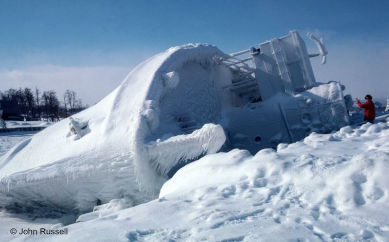
Fast forward 55 years, and you come to what is likely the most famous Michigan storm. The blizzard of 1978, which took place Jan. 25-27, was felt throughout the Midwest.
MichiganWeatherCenter.org calls it the worst blizzard in U.S. history. Governor William Milliken declared a state of emergency and called in the Michigan National Guard to aid stranded motorists and road crews. Cornish says there were reports in the range of 22-28 inches near Traverse City, and the Michigan State Police declared Traverse City “unofficially closed,” urging residents to stay home.
Unlike the White Hurricane, forecasters were able to alert the public prior to the storm. Blizzard warnings were posted across much of the Great Lakes and upper Ohio Valley region. Even after the storm passed, winter continued unabated. It had already been one the coldest seasons since records had been kept, from the Rockies eastward to the Appalachians. Temperatures were below normal in both January and February.
Winter 2001 offered a new take on happy holidays: A lake effect event during the holiday season that year saw at least three inches of snow in Traverse City every day from Dec. 24 through Dec. 30, aside from a paltry 2.4 inches Dec. 26. The heaviest accumulation took place Dec. 28-30, with 14.5 inches Dec. 29.
This was the same stretch that gave Petoskey its historic 78 inches of snow, with unconfirmed reports of 100 inches around the area.
Just over a decade later, the snowstorm that hit March 2, 2012, knocked out power throughout the region. Roads were closed as the plows were pulled off the roads. As much as 30 inches of heavy, wet snow fell in parts of Grand Traverse, Leelanau and Benzie counties, taking down power lines and leaving many of the rural parts of the area dark for days.
Leelanau, Benzie and Grand Traverse were under a state of emergency. Both electricity and phone service were down, as was cell service. Some in western Leelanau County found that driving to the beach in Empire provided cell service from Wisconsin.
Late-season storms can be just as devastating, especially when everyone is looking forward to spring and summer. So the storm of April 13-17, 2018 is another that immediately comes to mind for Cornish. He notes that many areas reported over 18 inches of snow during that four-day stretch, including the highest nearby total of 26.5 inches in Kalkaska. Maple City reported 20 inches, while Traverse City weighed in with 16.9 inches.
Though the totals might not seem dramatic across four days, Cornish says two things stick out to him. In addition to the high snowfall totals, prolonged accumulating sleet was experienced across much of the area on April 15. He says such a combination is very unusual.
The second is the timing. “This occurred in mid-April. The average snowfall for the entire month of April is in the single digits across our major observation sites, and is specifically 2.6 inches for Traverse City. Northern Michigan is certainly used to receiving snow at times all the way into the middle of May some years, but having a system bring 18 inches-plus to a large swath of the area is certainly impressive,” he notes. This system led to Traverse City experiencing its highest April snowfall total on record, at 27.1 inches – two feet more than the average.
That’s the Top 5 winter storms – though there is one more that merits consideration. This season’s early storm Nov. 2-3 2021 was enough to transform parts of Michigan's Lower Peninsula into a winter wonderland and break into the record books at the Gaylord weather station. The 11.7 inches of snow Nov. 2 set a record for the heaviest single-day snowfall in November. That amount also ranked as the sixth highest single-day snowfall in any month.
It was the first significant lake-effect snow of the season, dropping nearly a foot of snow near the shores of the Great Lakes over the two-day duration.
PHOTO: A toppled Allegheny during the blizzard of 1978, courtesy of John Russell.
Comment

Career Tech Center Student Scores Podium Finish In State Phlebotomy Contest
Read More >>United Way Will Host Nonprofit Volunteer Fair This Saturday At Commongrounds
Read More >>DDA to Talk Surveillance Cameras, TIF 97, Streetscape Policy
Read More >>Aerial Mobility Showcase Coming to TC
Read More >>


City Starts Leaf Pick-Up Monday
Read More >>Cops Hammering Grandview Parkway/M-22 Construction Zone
Read More >>City Commissioners Approve River Tours, Hickory Study; Reject Trespassing Ordinance
Read More >>Project Alpha, Facilities, Septic Ordinance on County Agenda
Read More >>The Big Three: TCAPS Eyes Central Grade, Central High, and Music Program Construction Projects
Read More >>Now Hiring! Spring & Summer 2025 Jobs
Read More >>